By Dr. Rula Samain
Some roads survive beneath layers of stone, others survive in memory; Jordan’s King’s Highway belongs to both.
Frequently described as one of the world’s oldest travel corridors, the King’s Highway is more than a road linking north and south, but a cultural landscape whose story is preserved through archaeology, geography, and one of history’s oldest written records.
Unlike Roman roads, which often survive through paved sections, milestones, and engineered remains, the King’s Highway was never a single monument waiting to be uncovered, rather, it is traced through settlements, valleys, water sources, mountain passes, and the logic of movement across Jordan’s highlands.
One of the earliest references appear in the Book of Numbers, as Moses requested permission to pass through Edom, he declared:
“We will go along the King’s Highway; we will not turn aside to the right hand or to the left.” (Numbers 20:17)
The same expression is repeated later in Numbers 21:22 and Deuteronomy 2:27.
From an archaeological perspective, this repetition is significant.
The biblical descriptions mention cultivated fields, vineyards, and wells, these are not merely as narrative details, but as elements of an inhabited landscape. The request not to leave the road suggests an established route passing through organised agricultural territories where movement was carefully managed. Rather than describing an isolated wilderness track, the text reflects a recognised corridor already integrated into daily life.
This observation corresponds remarkably well with the geography of central Jordan.
The Transjordanian plateau provides one of the few continuous north-south passages between rugged valleys to the west and the desert to the east.***
Archaeology increasingly supports this broader understanding.
Rather than revealing one continuous paved highway, archaeological investigations indicate a network of interconnected routes adapting to terrain, seasonal conditions, and local settlements. The principal corridor was likely accompanied by numerous secondary roads connecting villages, agricultural lands, water sources, and caravan stations.
This interpretation is reflected in archaeological surveys around Petra and southern Jordan, where researchers have documented an extensive transportation network rather than a single linear road.
Along this corridor stand some of Jordan’s most remarkable archaeological sites.
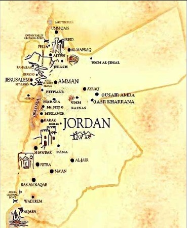
From Rabbath Ammon (modern Amman) through Madaba, Dhiban, Kerak, the dramatic crossing of Wadi Mujib, the highlands of Edom, and ultimately Petra, each location represents another chapter in the story of human settlement across Jordan’s plateau.
Among these, Dhiban offers one of the most important archaeological discoveries in the Levant.
The Mesha Stele, dating to the ninth century BC, records the achievements of King Mesha of Moab and provides invaluable insight into the political and cultural landscape of Iron Age Jordan. Although the inscription does not describe the King’s Highway itself, it confirms the existence of organised kingdoms, fortified cities, and sophisticated administrative centres connected through regional routes of communication.
Further south, Wadi Mujib, identified with the biblical Arnon, illustrates how geography shaped ancient travel.
Its spectacular canyon is not simply a natural landmark but a reminder that movement across Jordan required carefully selected crossings. Ancient roads rarely ignored the landscape; they responded to it. Valleys, ridges, and water sources determined where travellers could move, making the natural environment itself an essential part of archaeological interpretation.
One challenge remains.
Unlike Roman engineering, Iron Age roads often left surprisingly little physical evidence. Many consisted simply of well-established tracks repeatedly used by merchants, pilgrims, shepherds, and local communities. Centuries of erosion, agriculture, rebuilding, and continued use have altered or erased much of their original appearance.
This is precisely why reconstructing the King’s Highway depends upon combining multiple disciplines.
Biblical texts provide historical references, while archaeology reveals settlements and material culture.
Historical geography explains why specific routes emerged.
The landscape itself becomes part of the evidence.
Centuries later, following the Roman annexation of the Nabataean Kingdom in AD 106, the empire constructed the Via Nova Traiana, connecting Bostra in the north with Aila (modern Aqaba). Portions of this Roman road remain archaeologically visible today through paved sections, milestones, and engineered infrastructure.
Although the Roman route followed much of the same general north-south axis, scholars distinguish it from the earlier biblical corridor.
Rather than creating an entirely new road, Rome appears to have formalised and enhanced long-established patterns of movement already embedded within Jordan’s landscape.
Perhaps this is what makes the King’s Highway so fascinating; its significance does not depend on uncovering every meter beneath modern asphalt; its story emerges through the remarkable dialogue between text and terrain, between archaeology and geography, between ancient memory and the enduring landscape of Jordan.
For travellers today, the King’s Highway remains one of the world’s most extraordinary cultural journeys, not because every stone belongs to one period, but because every generation has left its mark upon the same timeless corridor.
Jordan’s landscape still tells that story for those willing to read it.
Following the King’s Highway Today
The modern King’s Highway is far more than a scenic drive through Jordan. For archaeologists and historians, it offers one of the world’s rare opportunities to travel along a landscape where thousands of years of human movement can still be traced.
Although the biblical King’s Highway cannot be identified as one continuous surviving road, today’s route closely follows the spine of Jordan’s central highlands—the same geographical corridor that connected ancient communities, kingdoms, pilgrimage destinations, and trade networks for millennia.
Travelling its length reveals how archaeology is best understood: not as isolated ruins, but as an interconnected cultural landscape.
Along the way, visitors encounter some of Jordan’s most significant archaeological and biblical sites:
– Amman (Ancient Rabbath Ammon) – One of the oldest continuously inhabited cities in the world, where Iron Age, Roman, Byzantine, and Islamic civilizations overlap within a single urban landscape.
– Madaba – Famous for the sixth-century Byzantine mosaic map of the Holy Land, offering one of history’s earliest cartographic representations of the region.
– Mount Nebo – Revered in biblical tradition as the mountain from which Moses viewed the Promised Land, while archaeological excavations reveal an important Byzantine pilgrimage complex.
– Mukawir (Machaerus) – The hilltop fortress of Herod the Great, identified by ancient sources as the place where John the Baptist was imprisoned and executed.
– Dhiban (Biblical Dibon) – Home of the Mesha Stele, one of the most important inscriptions ever discovered in Jordan and a cornerstone for understanding the Iron Age kingdoms east of the Jordan River.
– Kerak – A city where Crusader, Ayyubid, Mamluk, and Ottoman history sits upon a landscape occupied since much earlier periods.
– Dana Biosphere Reserve – A dramatic geological corridor that illustrates how terrain shaped ancient travel routes across southern Jordan.
– Shobak (Montreal) – A Crusader castle later transformed under Islamic rule, reflecting the strategic importance of the southern highlands.
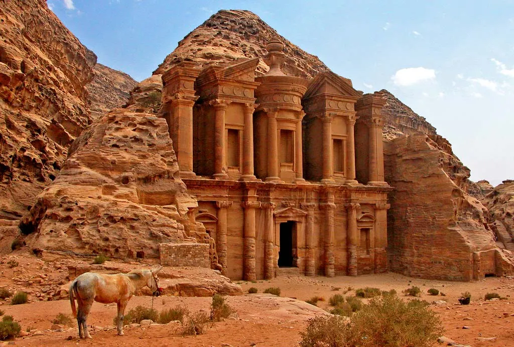
– Petra – The Nabataean capital, where sophisticated engineering, water management, and international trade transformed a mountain landscape into one of the ancient world’s greatest cities.
– Aqaba (Ancient Aila) – Jordan’s gateway to the Red Sea, where archaeology reveals continuous occupation from the Early Islamic period alongside evidence of much earlier maritime trade.
References
- The Holy Bible: Numbers 20:17; Numbers 21:22; Deuteronomy 2:27.
- Abudanah, F., et al. The Legend of the “King’s Highway”: The Archaeological Evidence. Studies on ancient road systems in southern Jordan.
- The Madaba Map, for the historical geography of the Holy Land and Jordan.
- Department of Antiquities of Jordan.
- American Center of Research publications on Jordanian archaeology.
- Council for British Research in the Levant archaeological research in Jordan.